Executive Director, South Florida Wildlands Association (Link).
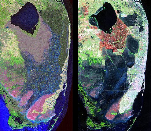
Photo on the left is not real - it's a simulation of the historic "pre-drainage" Everglades. What a satellite would have seen in the 19th century before the first major drainage canals were dug - if a satellite had existed. The Everglades is one massive interconnected system - slowly flowing - both above ground and below - from just south of Orlando to Lake Okeechobee and then south over the soggy shoreline of the lake to the River of Grass and Florida Bay. Photo on the right is what we actually see today. Drainage canals have allowed about 6 million of us - and many more tourists - to settle on Florida's lower east coast - while millions of acres of natural wetlands surrounding Lake Okeechobee in all directions have been drained for agriculture (sugar, citrus, and other crops) and cattle ranching. The water is laden with cattle waste, fertilizers, pesticides, urban runoff, and septic discharges.
A restored Everglades will be a system that looks - as much as now possible - like the photo on left. The more natural wetlands we bring back - the less load we will be putting on the system and the more mother nature can do what she's always done in South Florida. Want to really stop (or at least significantly diminish) the polluted discharges coming from Lake Okeechobee? Clean up the water before it gets to the Lake and bring back the wetlands that can receive that water like they did before. More to come.

 RSS Feed